
Study area
Bangalore capital, of Karnataka State, India is geographically located at the south eastern part of Karnataka state. The Greater Bangalore (Fig. 1) city is subdivided 8 zones with 198 wards under the jurisdiction of BBMP. Bangalore is geographically extending from 12°49‚5„ to 13°8‚32„N latitude and77°27‚29„ E to 77°47‚2„ E in longitude encompassing an area of 741 km2. Spatial extent of Bangalore has increased over 10 times between 1949 (69 km2) to 2006 (741 km2) and is the 5th largest metropolis in India(Ramachandra et al., 2012a,b; Sudhira et al., 2007) The population of Bangalore urban (BBMP limits) has increased by 48% i.e., from 5.84millon in 2001(Census, 2001) to 8.64 million (Census, 2011) in 2011. The population density in the region has increased from 7881 persons/km2 (2001) to 11 664 persons/km2 (2011).The topography (Fig. 1b) of the region is undulating, the altitude varies from about 740 m to over 960 m above mean sea in the region is main cause for formation of large number of drainages and storage tanks which are responsible for the local rains and cooler climate in summer. Temperature varies from 22°Cto38°C during summer and 14°C-27°C in winter. Bangalore receives an annual average rainfall more than 800 mm.
Since Bangalore is located on a ridge with natural water courses along the three directions of the Vrishabhavaty, KoramangalaChallaghatta (K&C) and Hebbal-Nagavara valley systems. The drainage allows the flows to cauvery through its tributaries Arkavathi (East flowing), Pinakini/Pennar (East Flowing) and Shimsha (West Flowing). The central, northern and eastern portion is undulating with the upland tracts occupied by scrubs, while the low lands occupied by series of tanks formed by embanking the streams along the valley for irrigation purposes. These valleys vary in size from small ponds to large lakes. The southern portion of the land consists of hills that are close together and are surrounded by scrub jungles and forests. Geologically the area consists of Granitic and Gneisses rocks in large scale (Bangalore District Gazetteer, 1981; Sekhar and Kumar, 2009), and other rocks include dykes dolerites, schist's.
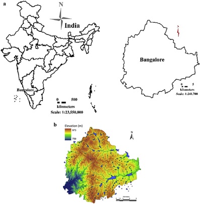
Fig. 1. a: Study area analyzed: Greater Bangalore e Silicon city of India. b: Bangalore's undulating terrain with interconnected lakes.
(For interpretation of the references to colour in this figure legend, the reader is referred to the web version of this article.)
Data:
Indian remote sensing (IRS) data were used in the analysis, the remote data was supplemented with datasets such as Survey of India topographic sheets of 1:250, 000 and 1: 50,000 scale, population census data (http://censuskarnataka.gov.in), online spatial data portals - Google earth (http://earth.google.com), Bhuvan (http://bhuvan.nrsc.gov.in) and field data gathered using precalibrated GPS (Global Positioning System). Table 1 gives the summary of the data used for the analysis.
| Data | Year | Description |
IRS Resourcesat 2 |
2013 |
Land Use Land Cover Analysis(Resolution 5.8 m) |
IRS Cartosat 1 |
2013 |
Land Use Land Cover Analysis(Resolution 2.7 m) |
SOI Toposheets |
|
1:250,000 and 1: 50,000 toposheets for delineating administrative boundaries, and geometric correction |
Bhuvan |
|
Support data for Site data, delineation of trees in selected wards |
Field Data |
|
For classification, location and canopy estimate of a tree, tree distribution in select wards, frequency distribution analysis and data validation |
Google Earth |
|
Support data for Site data, delineation of trees in selected wards |
Census of India |
1991, 2001, 2011 |
Population census data |
Table 1: Data used for the analysis.
